

Weekend storms expected in RVA
With 2 days in the upper 90s to close the work week

3pm, July 31, 2024
The short version
Hot and humid Thursday and Friday with isolated storms and temperatures reaching the upper 90s both days. The high humidity will send the heat index between 104-108 both afternoons (this has spawned the heat alerts from our colleagues at the National Weather Service in Wakefield).
More clouds return to the mix this weekend, with showers and thunderstorms much more likely on both of those afternoons. Still humid this weekend, but not quite as hot with afternoons in the upper 80s. That high humidity will keep the nights in the low to mid 70s through this weekend.
The tropics are a wildcard for our weather in Richmond next week (Aug 5-11). The best guess right now is that we will not get any direct impact from a tropical system, meaning a humid week ahead with afternoons averaging in the low 90s and lows in the low 70s. Chances for rain next week are otherwise low through Wednesday, but pick up for Thursday through the following weekend.
Full story: The 90s are back
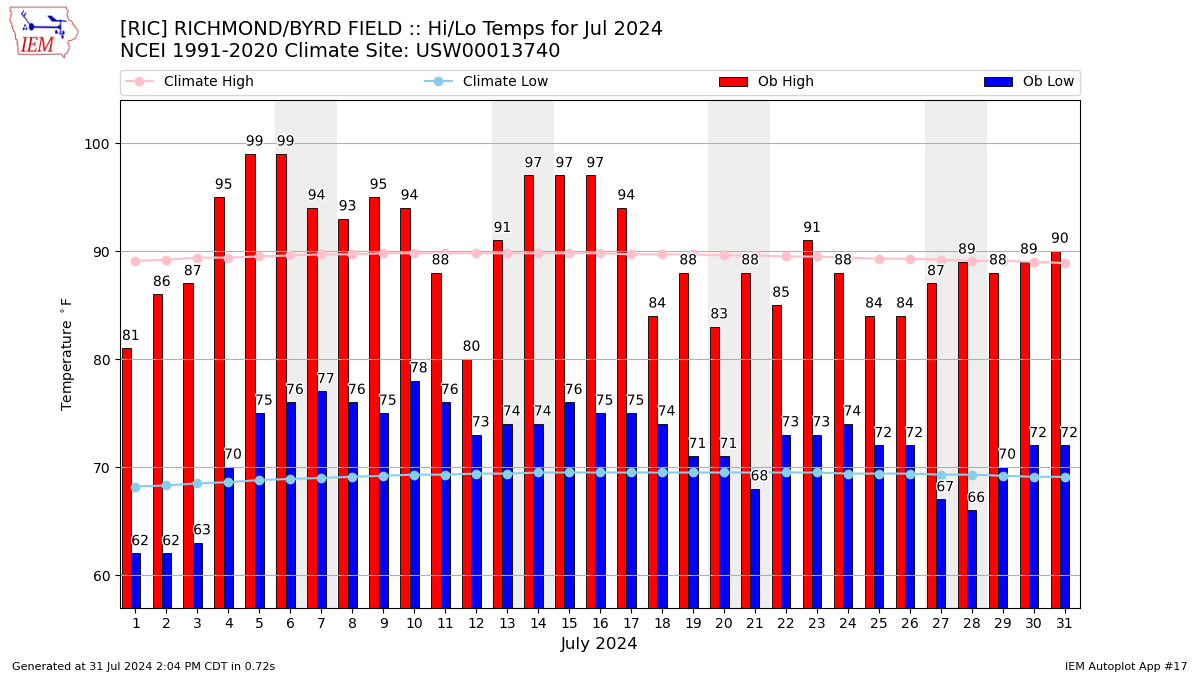
The previous two weeks have had only one day above 90 degrees (July 23) — until today (Wed). Both Thursday and Friday afternoons will surge toward the upper 90s.
The chance of showers and thunderstorms is low (20%) on Thursday and modest (40%) on Friday.
For this weekend, showers and thunderstorms are expected (70%) on Saturday and likely (60%) on Sunday as a broad area of low pressure in the upper atmosphere swings by.
Timing of the rain is tricky this weekend, but the classic 4-8 pm window seems the best call right now. Otherwise, it will continue to be humid with afternoons near 90 and daybreak temperatures in the middle 70s. For outdoor activities either day this weekend, have an indoor back up plan and be ready to implement it.
Tropical Wildcard
Early next week in Richmond depends on what comes forth from the tropical Atlantic. As mentioned last week, a small tropical disturbance (often referred to as a wave) is taking shape near Puerto Rico this Wednesday afternoon. Over the weekend, the betting money is for it to become a tropical depression in the general neighborhood of the Bahamas.
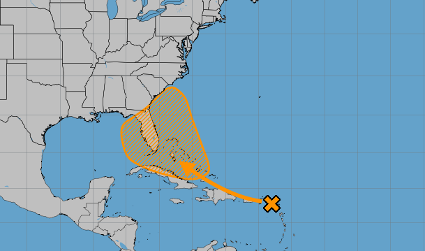
The initial window of concern for Virginia is Monday through Wednesday of next week (Aug 5-7). But there are two other important points:
First, there is no reason to believe a hurricane is coming. There is enough evidence to suggest a tropical storm will be within a few hundred miles of Richmond and our favorite North Carolina beaches early next week. This could bring some rainy spells and 20-30 mph winds for a day or two, depending on the track. But this is far from being likely.
Second, there is also evidence, although not as strong, that this system does not turn north early next week. Rather, it drifts westward toward Florida and perhaps into the eastern Gulf of Mexico. From that point, it might slowly drift north again, or perhaps move northeast along the Southeast coast toward the end of next week. That may also spell rain in Richmond or along the Outer Banks.
The end result: There is just too much uncertainty right now to take any specific action. Follow it more closely starting on Friday and pay attention over the weekend, as the end result will go a long way in determining our weather in Richmond next week.
If you are going to the beach this weekend, this will not be a problem, and if you have a week at the Outer Banks next week (Aug 4-10), there is no reason to cancel it. But check about once a day while you are down there next week to see how it plays out. If this storm takes a name, it would be called Debby.
I like to use a Star Wars analogy. There is a disturbance in The Force. The precise what, where, and when are still a matter of discussion. Just don’t get caught off guard this weekend and find yourself surprised on Monday morning.
Climate Pileup
July will be the 8th consecutive month warmer than normal in Richmond, driven by the low temperatures more than the highs.
This July had 25 nights that were at least 70 degrees. If you think that number has jumped over the past several years, you are correct.
Going back to the start of Richmond’s daily weather records in 1897, the average number of 70°+ nights in July is 15.
This will be the 10th consecutive July above that average, and 14 of the last 15 Julys have been above that average.
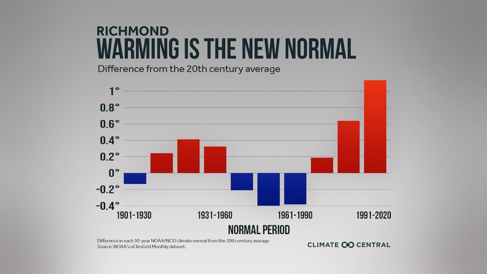
Normal temperatures, which we hear about a lot, are 30-year smoothed averages calculated every ten years. What we have seen recently matches very well with the new normals released earlier this decade.
And 2024 may not be the hottest year on record so far in Richmond, but there are two statistics to watch now that July is coming to an end. So far this year in Richmond it has been:
3rd warmest summer on record (behind 2010 and 2011)
2nd warmest year on record (behind 2012)
August Outlook
Early data suggests August will add to that list, with odds favoring another month warmer than normal, and rainfall slightly favored to be above normal.
More specifically about rain, look for about 2-3 inches through the middle of August — pretty close to normal. That will be enough to keep serious drought away from Richmond.
But spare a thought for our friends in the Shenandoah Valley, as extreme drought continues there.