

Splendid summer weekend ahead for RVA
A nice drop in humidity comes just in time

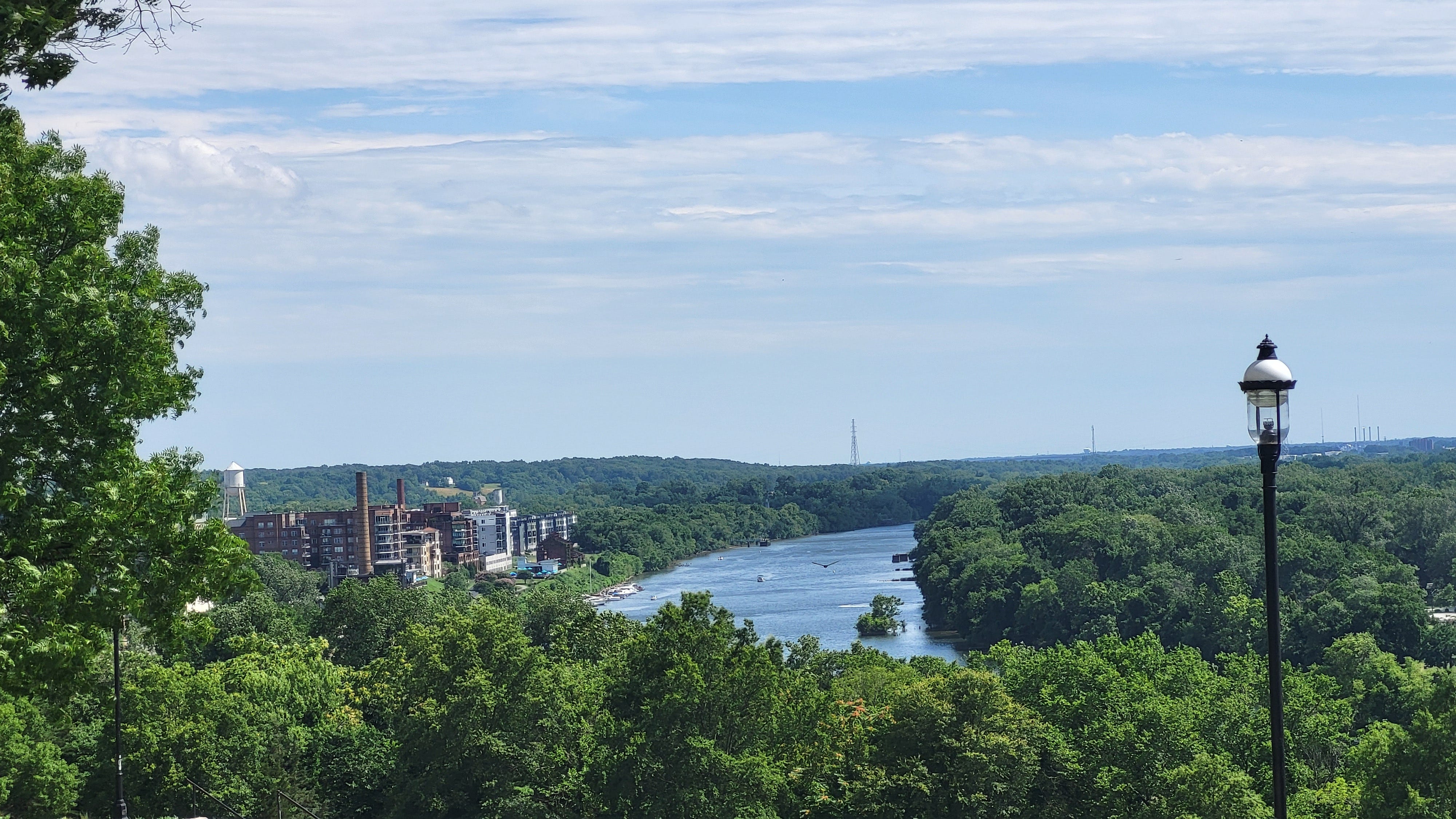
3pm, July 24, 2024
The short version
After another round or two of showers Thursday, drier air filters in Friday, making for a seasonably warm, but noticeably less humid weekend in Richmond. Shower and storm chances are pretty good again for a couple of days next week, and it will be time to watch the tropics again soon.
All rain is not created equal
As expected, the overall weather pattern has not changed much since last weekend. A broad area of southwest winds aloft has kept humidity high with spells of showers and thunderstorms, eating away at the drought.
There have been a few intense spells of rain and some areas of flash flooding around Richmond since last weekend, but a drier weather pattern is about to return. That pattern begins with a nice weekend — temperatures near normal and significantly lower humidity.
Since last weekend, a broad 1-2 inches of rain has fallen across Richmond, but because the rain comes in small batches of showers and thunderstorms — some more intense than others — the totals vary quite a bit.
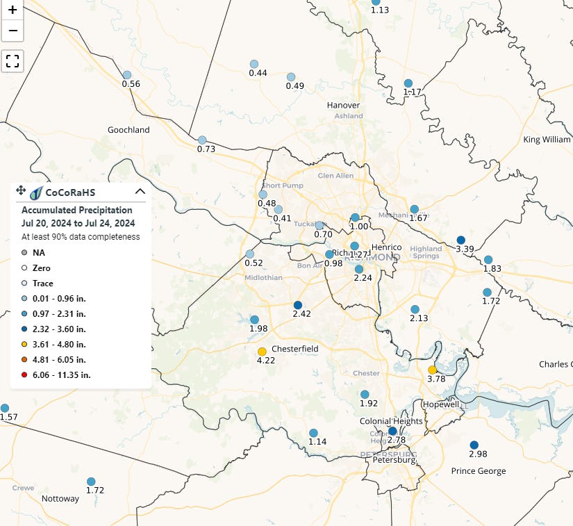
Away from the 1-2 inches across the city limits (this afternoon’s rain not withstanding), there has been less than a half inch westward to Short Pump, but more than 3 inches in southern Chesterfield County — that 4.22-inch measurement above is near Harbour Green, just off of Hull Street Road (US 360).
Since the first of July, 7.33 inches has fallen in Richmond — as heavier pockets of rain have been more common at the observation site at Richmond International Airport. But across the metro area, 5-7 inches has been more representative for the month, and further west toward Short Pump and Tuckahoe, there has been less than 3 inches this month.
Such is the nature of showers and thunderstorms in the summer.
Beneficial rain has also fallen westward toward Lynchburg and Roanoke, but in the Shenandoah Valley where statewide drought is the worst, amounts have not been as generous — more like 1-3 inches since the first of the month.
A break in humidity this weekend
After a few more showers and thunderstorms scatter around metro Richmond through Thursday night, the rain shuts off for a while. This drier air slowly filters in after dawn on Friday, cutting back the chance for showers and storms dramatically, meaning both days this weekend look sunny with nearly zero chance of rain.
During those couple of days, the winds aloft will turn from the west, then northwest. This will allow air from southern Canada to flow into Virginia. Although the air there is not really cool, it is less humid. This yields a perceptible and pleasant drop in humidity for a few days — conveniently coinciding with the weekend. Both days this weekend look mostly sunny with afternoons in the middle to upper 80s.
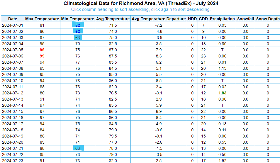
You may notice it more at night, as the drop in humidity will allow nights to cool off more than they have in a couple of weeks. Since Independence Day, there has only been one night below 70° in Richmond. Both Saturday and Sunday nights should dip toward the middle 60s, making it one of the nicest weekends of the summer.
Just remember the sunscreen.
10 day outlook
The leading edge of hotter and more humid air that holds west of the Appalachians over the weekend will inch into Virginia on Monday, and may spawn some isolated afternoon showers and thunderstorms.
Heat and humidity gradually build for Tuesday through the end of next week. Oppressive heat is not expected, but afternoons will edge into the lower 90s for the second half of the week. Humidity will return to the levels we have dealt with over the last couple of weeks as those northwest winds aloft switch back to the southwest.
This also means the chance for showers and thunderstorms returns to the forecast on Tuesday and Wednesday next week. Right now, the chances look a little better on Wednesday versus Tuesday. Then chances decrease again for Thursday and Friday.
Specifically for next weekend (Aug 3-4), the chance for showers and storms looks a little better on Saturday versus Sunday, but this far in advance, it is too early to change any outdoor plans. Afternoons next weekend are probably near 90 with lows in the lower 70s.
Tropics
There is nothing imminent in the tropical Atlantic, but there are repeated suggestions in the weather simulations over the last two days that a cluster of thunderstorms will emerge off of the west African coast and march across the Atlantic Ocean during the next week to 10 days.
To be clear, this does not mean a hurricane is coming. However, this is a signal to start paying attention again to the tropics starting early next week. The simulations are clustered around an idea that a system will wander through the Caribbean around August 1, then continue northwestward toward the Bahamas or Florida a few days later.
However, it is far too early to take any of these simulation as correct final answers. They simply tell us that after a quiet few weeks, the tropical Atlantic is about to wake up.
Astronomy
You’ve probably noticed the sunrises are getting later — and the sunsets a little earlier — as we are losing about 1:30 of daylight each day through the end of July. The decrease accelerates in August, losing at least 2 minutes each day starting on August 10.
But there is still plenty of summer ahead. The first sunset before 8pm in Richmond does not occur until August 17.
