

Recurring rain ahead for RVA
And more to monitor in the tropics

5pm Wednesday, September 24, 2025
The rain that moved into central Virginia on Wednesday afternoon signals an extended period of showers that stays with us through this weekend — and perhaps early next week.
A weakening cold front, which is the leading edge of advancing cold air, is approaching Virginia from the west. But it will stall, acting as the focus for occasional showers over the next couple of days.
Thursday and Friday will have a late summer feel, with warm days and the threat of showers. However, most of the time it will not be raining — just warm and humid with clouds and sun as afternoons reach the 80s and nights fall into the upper 60s.
For the weekend, it increasingly looks like a disturbance moves in from the south and brings a more consistent rain to Richmond — several hours worth on Saturday afternoon and evening — before ending as some lingering showers on Sunday. The higher humidity means it would not be a cold rain, with temperatures in the upper 60s while the rain falls, and nudging into the 70s otherwise.
Atmospheric Fight
There is even less certainty next week, as two main features will be competing for weather influence over Virginia.
A large cell of cool and dry high pressure will be moving south from the Great Lakes on Monday. But at least one, and perhaps two, tropical systems will approach the Southeast coast early next week.
Precisely how those systems interact will determine how the weather from Monday through Wednesday plays out here.
In the wake of that interaction, the cool and dry cell of high pressure will ultimately win out, moving far enough south to bring Richmond a sunny, cool, and dry period for the second half of next week. That would bring Thursday through Saturday a distinct feel of fall — appropriate for early October — with afternoons near 70 and nights into the low 50s.
Tropics
The unusual lull in the tropics has ended, with Hurricane Gabrielle now racing eastward across the middle of the Atlantic Ocean, probably impacting Portugal and Spain toward the end of the weekend.
But there are two systems to monitor closely during the next several days that are taking shape near the Caribbean, and because they are forming so close to one another, their interaction introduces another variable into complex intensity and track forecasts.
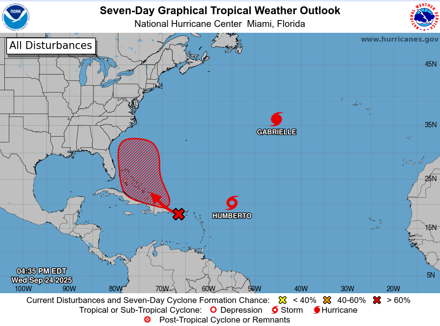
The western system (known as 94L) poses the greatest risk to the Southeast coast. However, it still needs to move out of the Caribbean Sea and will interact with the islands of the Bahamas, which would hamper its early development.
As a result, its full development into a strong tropical storm or hurricane may not happen until it reaches the area between the Bahamas and the Southeast coast, which would not happen until the end of the weekend. It will be the slower of the two systems to develop, so if it does take on a name, it would be Imelda.
Most of the data suggest future Imelda will turn back out to sea shortly before coming ashore along the Carolina or Georgia coasts, but given the weak steering winds forecast later this weekend, it is wise to closely monitor the Southeast coast toward the end of this weekend and early next week.
The second system, Tropical Storm Humberto, has already developed a noticeable circulation east of the Caribbean Sea. We expect it will strengthen as it continues moving northwest, becoming a hurricane in the next 2-3 days. However, there is strong evidence that Humberto is going to turn north, then east, and back out to sea long before it reaches the East Coast.
Nonetheless, it may come close to Bermuda as a hurricane late this weekend or early next week.
Outlier
There is one scenario in which future Imelda moves several hundred miles into the Atlantic next week before an unusual shift in the steering winds sends it back to the East Coast during the weekend of October 5.
While certainly not impossible, we would want to see additional data pointing to this idea over the next few days before giving that scenario any real headspace.
The other job
Last weekend, I was in Williamsburg talking to people about the core components of my 2026 campaign for Congress in Virginia’s First Congressional District: costs of living, healthcare, civil rights, accountability, and the environment.

If you missed our introductory video, take a look below, and share.
If you are as frustrated as I am with the state of politics as usual, we could use your support at seanforva.com. More than 1700 people have donated to the campaign, and while we are happy with our progress, we still need to make our financial goal by the end of the month. We’ve decided not to take any corporate PAC money, to be certain our values are not compromised.
I know one person in Congress, my friend Eric Sorensen. He is the only other meteorologist in the House of Representatives, and he was kind enough to publicly endorse me:
Check our positions and we welcome your support at seanforva.com
Thank you!