

Rain ends and cold air returns
Cold not as bad as earlier in the month

3pm Wednesday, December 11, 2024
Cold air is about to come back, but not as intensely as earlier in the month. A more typical December weather pattern is ahead over the next couple of weeks, with no prolonged deep cold, but no extended warm up either.
As the cold air surges in on Wednesday night, temperatures from Thursday through Sunday will hold a few degrees below normal. Afternoons will average in the mid to upper 40s with daybreak temperatures in the upper 20s through Saturday.
Normals for this week in December are in the low 50s (highs) and low 30s (lows).
Weekend preview
Once Wednesday afternoon’s rain ends, no more rain is coming through Saturday, and if you need to get something done outside this weekend, Saturday is the suggestion.
A healthy disturbance will approach Virginia on Sunday, but the precise timing will make the difference between sun giving way to clouds or a few spells of light afternoon rain.
And any precipitation that does fall will just be rain (i.e. no ice, no snow). Temperatures will be safely into the 40s, and perhaps even low 50s during the afternoon.
Ups and downs next week
Monday looks dry (depending on the speed of the Sunday system), then another weak disturbance drags clouds and some showers through on Tuesday. Milder air will hold for a couple of days early next week, with afternoons in the 50s to near 60 and lows in the 40s.
A couple of quiet and seasonable days follow before larger disturbances approach late next week and perhaps into the weekend of the 21st.
Precisely what those disturbances mean for Virginia is an open question, although the first thought would be for rain Thursday and/or Friday, with those systems gone by daybreak on Saturday the 21st.
Regardless, in the wake of those systems, a more potent surge of cold air returns, suggesting Saturday and Sunday (21st-22nd) will be dry, but a bit colder than normal with afternoons in the low-mid 40s and lows in the mid-upper 20s.
For White Christmas fans, the odds are stacked against you. Sure, much can happen in the next couple of weeks, but there is not much in the data to get excited about when looking this far in advance. After all, the climatological odds of a White Christmas in Richmond are only about 6 percent.
Cold climate review
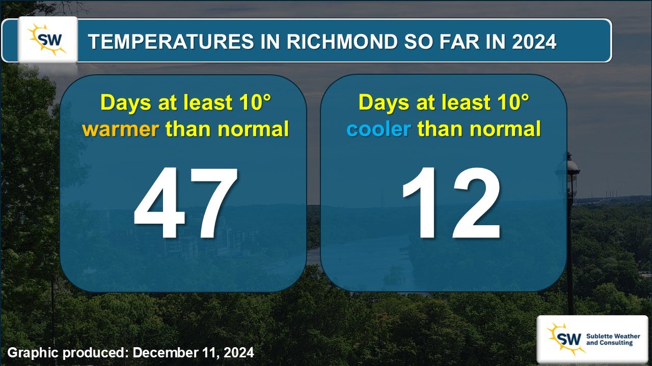
The cold start to December may have felt like a shock, but we broke no daily temperature records during that period. However, since Thanksgiving, we have had six days that were at least 10 degrees colder than normal.
Before that, we only had six such days during the entire calendar year — and four of those were in January. In spite of our recent cold spell, Richmond remains on track to have its warmest calendar year on record in 2024.
Another odd statistic that we have quietly been building is the consecutive number of days that have reached the freezing point. Obviously the afternoons are well above freezing between spring and fall, but on occasion during the winter, Richmond can still find itself within a deeply cold air mass or a modest snow, keeping the high temperature for the day below freezing.
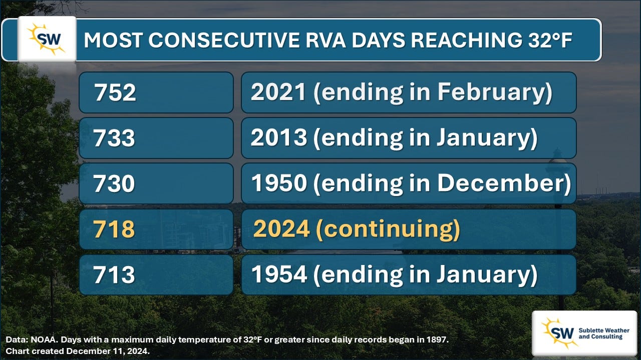
But that has not happened for 718 days and counting — the 4th longest stretch on record. No bitter cold is on the horizon for at least a couple of weeks, which means we will probably push into third… or even second place.
There are signs of an especially cold spell in the middle of January, but it’s still a bit early to be sure.