

Impacts from Hurricane Erin
And a hint of fall in the air later next week

5:15pm Wednesday, August 20, 2025
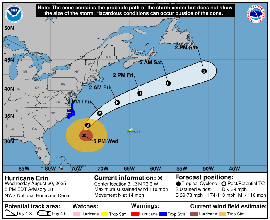
Hurricane Erin has not strayed too far from expectations, at least with regard to the track. The intensity forecast has been good, but not as good as we might have liked.
Late this afternoon, its center was about 300 miles south-southeast of Cape Hatteras, and it has started its movement north. It will move no farther to the west now, and every expectation is that it will turn northeast over the next 12 hours, keeping its core offshore.
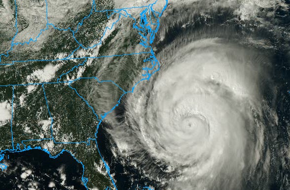
Erin is a Category 2 hurricane — its strongest sustained winds are 110 mph. Those winds are located in the circle of clouds surrounding the eye — the eyewall.
While the center and its core of most intense winds are important, it is critical to remember that no hurricane is a singular point, and secondary impacts from a hurricane extend far away from the center.
That is the case with Erin.
Below are the projected sustained wind speeds from the ECMWF model. Remember that sustained wind speeds are 2-minute averages, and gusts are often up to 50 percent stronger. Blue shading is generally 10-20 mph, which covers most of Virginia between the Blue Ridge and the Chesapeake Bay.
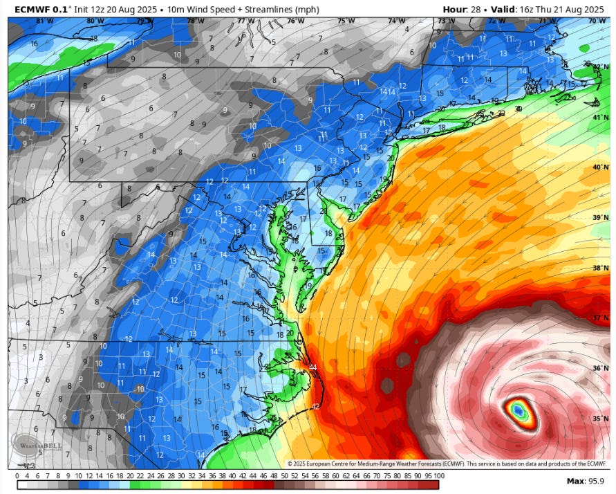
Notice the lines with the arrows? Those are streamlines that tell us the direction of the wind, and for the most part, the winds will be from the north in Virginia when they are strongest on Thursday.
For inland waterways away from the Atlantic coastline, like the tidal parts of the Rappahannock, York, and James Rivers, there will be 1-2 feet of coastal flooding during high tides through late Thursday night. Much of Southside Hampton Roads (Portsmouth, Norfolk, Virginia Beach) will have similar levels of high water.
Tropical Storm Warnings
The blue-shaded area indicates the areas under a Tropical Storm Warning, which means that sustained winds of 39 mph or more are expected within 36 hours. That will probably be the case at the oceanfront from Wallops Island on the Eastern Shore southward to Cape Lookout in North Carolina.
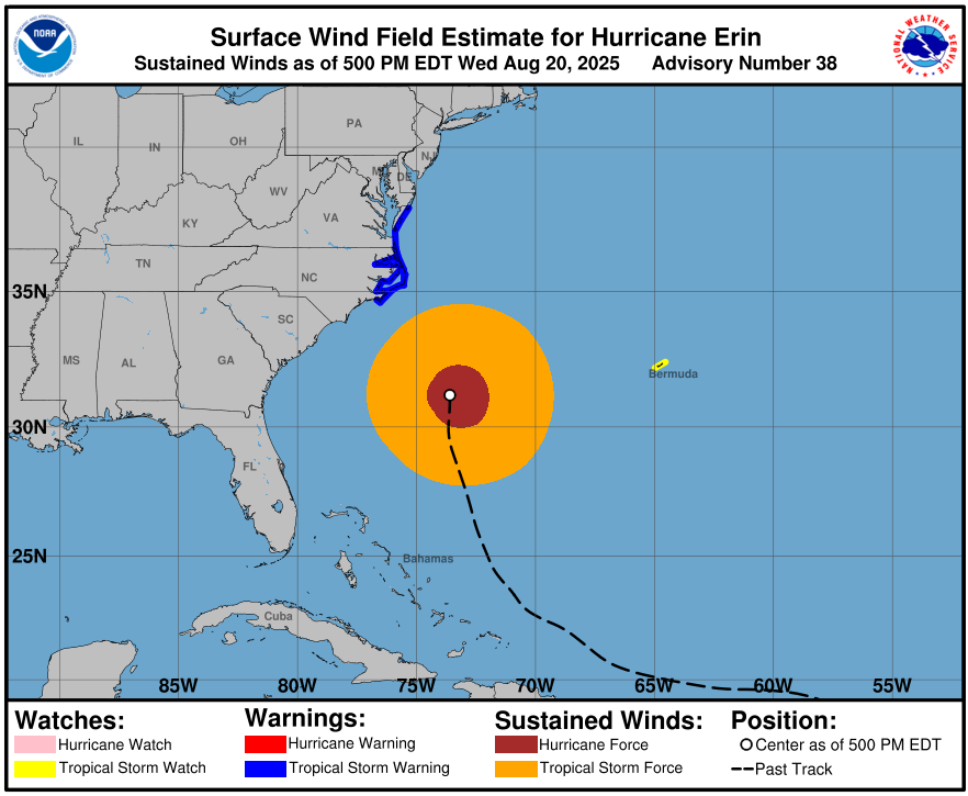
If you remember the old Beaufort Scale, that strength of wind corresponds with Force 8. Also known as a gale force wind (sometimes called a fresh gale), that is the level at which twigs and small branches begin to break from trees, walking against the wind becomes more difficult, and cars will begin to veer slightly while driving.
What follows the hurricane
Other than the wind in Richmond, there will be some cloudy periods and perhaps a couple of showers, but no consistent rain on Thursday.
By Thursday night, Erin will accelerate northeastward into the North Atlantic, and weather in Virginia will quiet down.
The sun will be back out Friday and Saturday in Richmond, there will be a nice dip in humidity, and the afternoons will hold in the lower to middle 80s. Nights will fall well into the 60s.
Another system approaches Sunday into Monday, and will probably squeeze out a few showers or perhaps thunderstorms, and in its wake will be an even cooler and less humid period that will get a lot of people talking about an early start to fall.
That unusually cool airmass will spend a few days in Virginia next week, keeping temperatures significantly below normal. Tuesday through Thursday next will have afternoons in the 70s to lower 80s, and we might get our first night in the 50s since the first week of June. The the chance of rain those three days will be small, but not quite zero.
Although this does not mean that summer is over, the data point to temperatures near or below normal through Labor Day Weekend. With our winds up at the jet stream level from the west or northwest through early September, it will be difficult to get legitimately hot.
So you can put the fear of afternoons in the 90s away for a while.
Campaign update
As many of you know know, I am also running for Congress in Virginia’s First Congressional District. The election will be in 2026. Read more about our platform here.

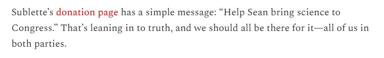
I was happy to get the attention of Jill Lawrence, a contributor to The Bulwark, who took note of our aim to bring science, data, and evidence back into the House of Representatives in 2026. Her story closes:
The full essay is here, emphasizing the growing momentum of medical and other scientific professionals running for office.
Meeting Scott “K”
And I was also happy to meet Scott Konopasek (below), who served as an Army Intelligence Officer — with overseas and combat tours before he retired. A true American patriot, he is running for the Virginia House of Delegates this fall in Hanover and Louisa Counties (59th district), and would be a welcome change from the incumbent, who does not even live in the district he claims to serve.

We’ve been very happy with how our campaign has been going since launching a couple of weeks ago, and if you are ready for a new voice — not the same recycled politicians — to get rid of the conspiracy theories and use data and evidence to get results for Virginians, my team and I would be grateful for a contribution to our campaign, or sharing our campaign with your friends.
See more of what we are about at seanforva.com
And thank you!