


4pm Wednesday, July 16, 2025
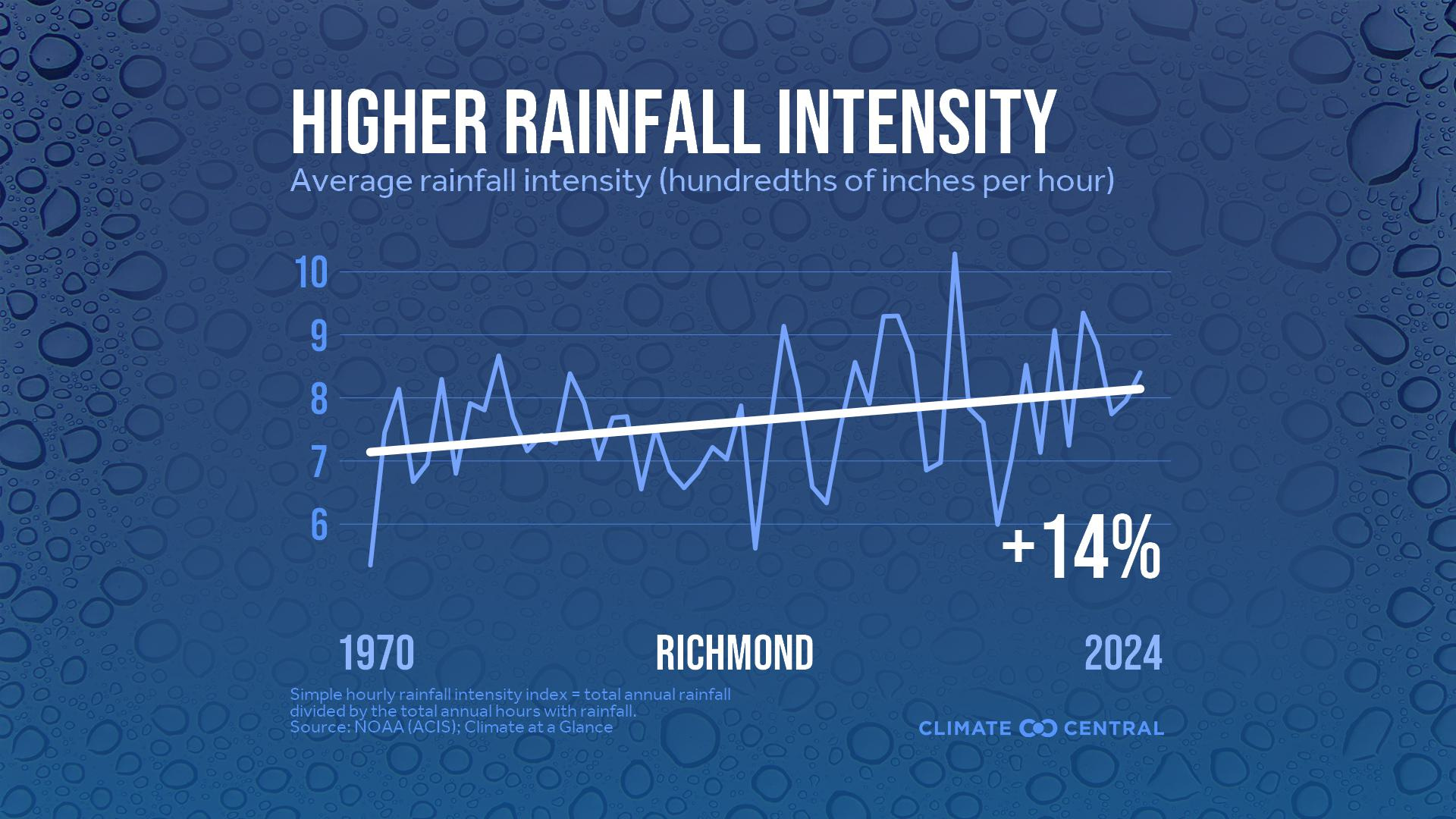
The first half of July in Richmond has been the wettest first half of July on record. With 9.93 inches of rain (at the observation site near Sandston) through the 15th of the month, it would also finish as the 9th wettest July on record even if no more rain fell for the rest of the month.

However, the nature of summer thunderstorms invariably means some locations get more rain than others. That is to be expected this time of year.
Compared to the larger storm systems that bring widespread rain during the fall, winter, and spring, summer thunderstorms are smaller with a shorter life span (we call that mesoscale in our line of work). However, because it is so much more humid in the summer, they can produce far more rain in a shorter amount of time, which is why flash flooding is a greater concern in the summer.
Thunderstorms, like those of the last couple of weeks, form like bubbles at the bottom of a pot of slowly simmering water. As a result, big differences in rain totals show up across a metropolitan area.
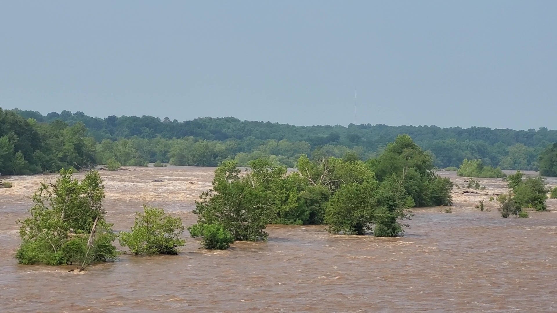
Much of Dinwiddie and Prince George Counties, along with Petersburg and Colonial Heights, have had 4-7 inches of rain over the last 72 hours. Like many urban areas, the infrastructure in Petersburg is simply not in place to deal with that amount of rain in such a short period.

Shannon Heckt at the Virginia Mercury reviews the Petersburg situation.

Rainfall has not been quite that high in Richmond over the last three days. Nonetheless, it has been plenty wet. Totals across RVA since July 1 are on the map below:
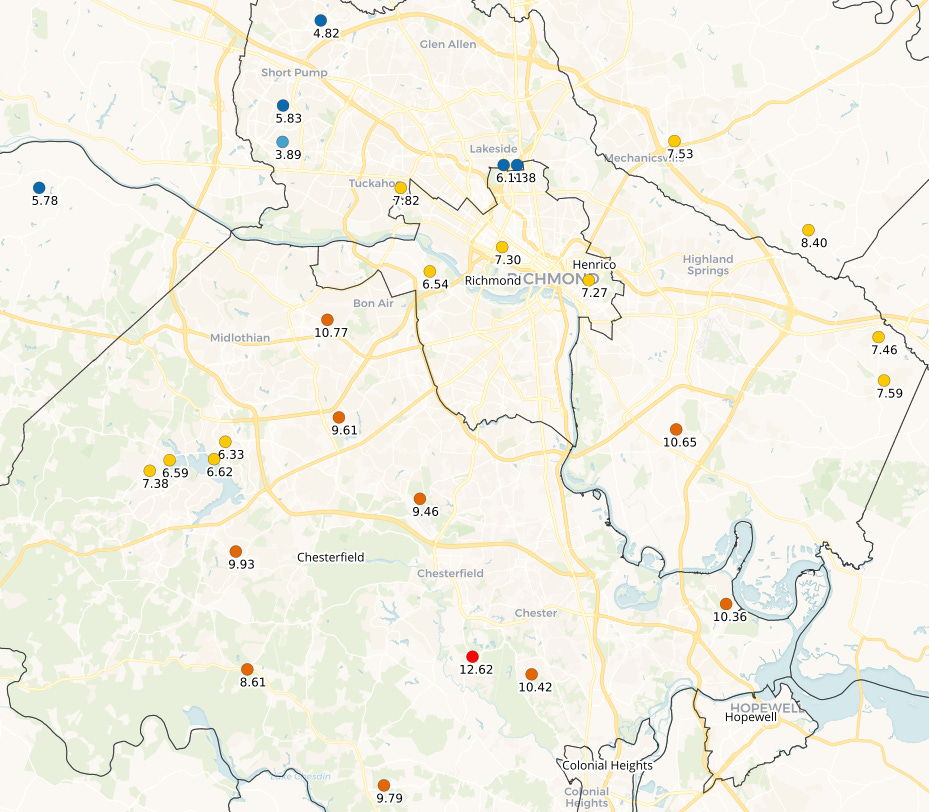
In general, 6-8 inches has fallen so far this month in the city limits of Richmond, while 8-12 has been more common in Chesterfield County (slightly lower amounts toward Brandermill and Moseley).
Western Henrico County, toward Glen Allen and Short Pump, has received about half of that — between 4-6 inches of rain this month.
How much longer
In a broad sense, there will not be massive changes to the weather pattern for the next few days. Thursday and Friday will be hotter — into the 90s — and there will be an easing of the thunderstorm threat on Thursday, although it does come back for Friday and the weekend.
There are small signs of a break in humidity for a couple of days early next week, but nothing that would feel like fall. After all, this week is the climatologically hottest week of the year in Richmond. Nights well down into the 60s would be an atmospheric gift.
Trying to put the odds of getting a shower or thunderstorm over the next 4 days at any one place in Metro Richmond:
30% Thursday
60% Friday
60% Saturday
40% Sunday
One thing to emphasize: there is no way to know for certain if you will get a specific amount of rain in your neighborhood on any given day over the next 4 days.
There’s just not. Believe me, I wish there were.
That type of highly precise thunderstorm forecasting in time and space is still out of reach. As a result, probability forecasting is the best way to prepare for the uncertainties that come with thunderstorm forecasting this time of year.

Flooding and reacting to it
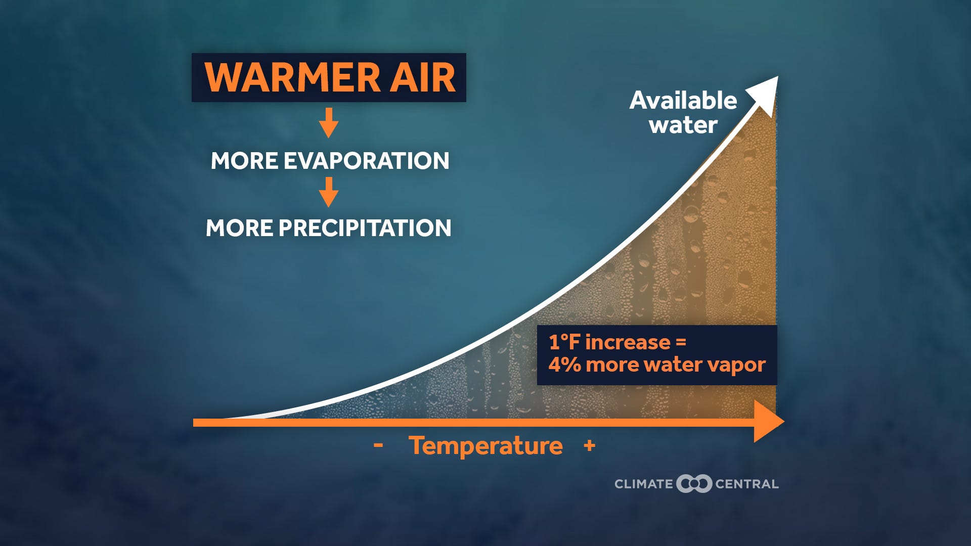
With so much flash flooding in the news nationally over the last couple of weeks, it is worth a reminder that the weather pattern is what leads to heavy rain. But the warming climate allows more water to evaporate into the atmosphere, so that the heaviest rain is getting heavier. The physics and the data bear this out.
But how we plan and react to flooding depends on us.
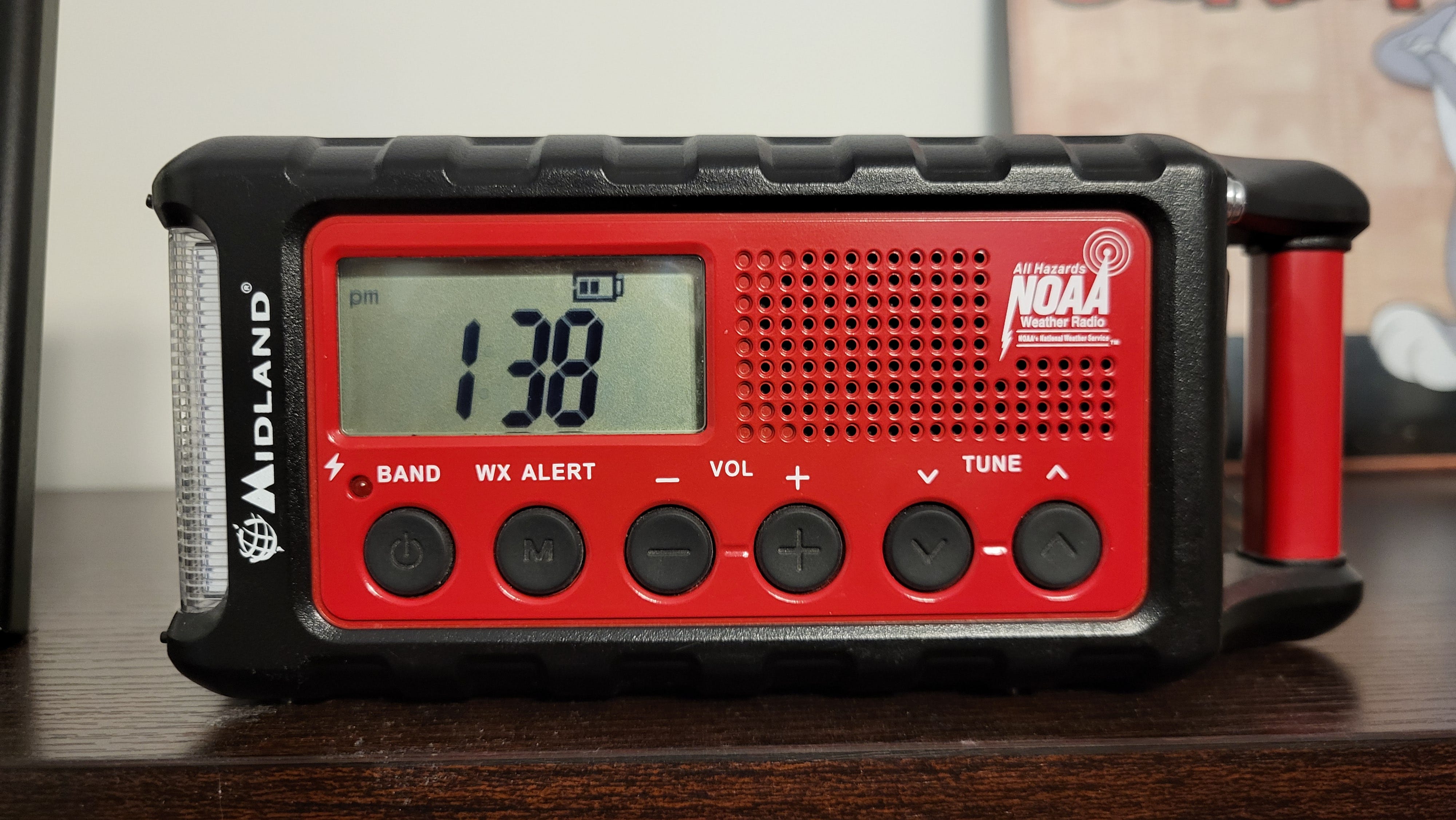
There are lots of ways to get weather warnings, and we could talk about warning fatigue, crying wolf, and outdoor sirens ad nauseum. However, there is one failsafe way of getting warnings that is still out there, though it has nearly been forgotten about since mobile phones became commonplace — the weather radio.
Sadly, we have to talk about this in the weather news again. As even the weather radio network is under attack by this Administration.
Earlier this week, the Administration apparently ordered a partial discontinuation of the transmission contracts related to NOAA Weather Radio (NWR). Also known as all-hazards radio, it was the primary method the National Weather Service (a division of NOAA) used to relay weather warnings to the public during the middle to latter 20th century.
That radio transmission infrastructure remains in place today, and it is a good backup in the event of an electrical grid failure or in places that wireless mobile networks are not available (or have been compromised).
This is a very new story, and my colleague Alan Gerard unpacks it in his Balanced Weather Substack. Alan retired after 35 years with NOAA and explains this far better than I can.
But a quick takeaway here from his analysis:
“I would think this is a serious concern for the NWR program as it could require NOAA to try to find new tower space for a number of NOAA Weather Radio sites, which I expect would be a very daunting task for local and regional NWS offices already under a lot of strain for other reasons (mostly relating to other administration activity).”
Several NWR transmitters are scattered around Virginia, and the one that serves Richmond is on the tower behind the State Police facility on Midlothian Turnpike (between Chippenham Parkway and Buford Road).

Weather radios are inexpensive, and modern ones have rechargeable batteries with a very long battery life. And yes, I have one.
The model below was about $40 when I got it ten years ago, and it still works great. At the risk of sounding like a salesman, Midland is a trusted name in our business. If you are curious, take a look at some of their radios.
One other note when you get some type of flash flood warning, take a moment to pay attention to the full text of a warning if you can. The reality is that some Flash Flood Warnings will be more urgent than others.
In truly dire situations, a Flash Flood Warning will include the terminology of Flash Flood Emergency. While rare, that wording is very specific and demands immediate attention.
If you were in Richmond 21 years ago for the flooding from Tropical Storm Gaston, that is the type of thing that qualifies as a Flash Flood Emergency.
Stay safe, dry, and cool over the next few days.