


5pm Wednesday, May 28, 2025
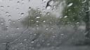
Although there will be showers scattered across Virginia on Thursday, Friday, and Saturday, the steady soaking Richmond had on Tuesday and Wednesday has ended, with 2.07 inches of rain during the 30 hours ending 2pm Wednesday.
This brings the monthly total to 6.33 inches, the 15th wettest May on record in Richmond. With additional showers and thunderstorms (most likely on Friday), we have a chance to get into the top 10 (6.85”), but a record wet May is out of reach.

You may notice 3 of the 5 wettest Mays on record have come in the last 25 years.
Broadly, the planet has warmed about 2°F over the past 100 years — one of the strongest signals of the warming climate.
A warmer atmosphere can evaporate more water — from soils, rivers, bays, and oceans. In turn, it falls as heavier precipitation.

Not all rain is heavier, but the heaviest rains have become more intense, which contributes to additional flooding risk of streams, creeks, and rivers. There is unquestionably an annual variation to storms, their track, and their intensity, but the average precipitation rate in Richmond has shown a modest trend upwards during the last 50 years.

Ready for the Weekend
For short term weather, a quick warming trend is ahead. Thursday brings sun and clouds, and while a quick shower or two is possible, this is probably a miss for Richmond — as the afternoon bounces back to around 80 degrees.
However, a more potent system races through on Friday. Unlike the recent prolonged rain, this one will spawn a couple of rounds of quick-hitting showers or stronger thunderstorms late in the afternoon or into the evening. Those will have the potential to produce hail or damaging winds, so be ready for them if you plan to be outside late Friday (you know, the Greek Festival is back in town this weekend).
Saturday brings a final disturbance that spawns some small showers for an hour or so in the afternoon, then a legitimate drying period begins on Sunday, and continues well into next week.
No rain is expected Sunday through Wednesday, and afternoons will get a little bit warmer each day, into the upper 80s by Wednesday.

Hurricane Season is back
This Sunday, June 1, marks the start of the Atlantic hurricane season. Like last year, it is expected to be an active season — with a few more storms than normal.
But remember, the core of the season is from the middle of August to the middle of October, when the water across the Atlantic Basin (including the Gulf of Mexico and the Caribbean Sea) is warmest.
An average season has about 14 tropical storms becoming strong enough to take on names, with half of those going on to become full hurricanes — where the strongest sustained winds around the storm’s eye are at least 74 mph.
Although wind damage does occur in Richmond from tropical systems, rain and flooding from them tend to leave the deepest scars.
Richmond’s worst James River floods of the modern era came from topical systems. Camille (1969) and Agnes (1972) lead that list, with third place coming from a hybrid system that had tropical moisture involved from Juan in 1985.
All three of those James River crests were higher than 25 feet at the Huguenot Bridge gauging station, where flood stage is 12 feet. Not surprisingly, these floods helped spark the idea of the floodwall which has been in place since 1995.
We have been nowhere near those James River levels in a long time. During the last 25 years, the highest crest was 18.7 feet, coming in February 2003, far down the list in 21st place.
Hurricanes and climate change
Rainfall in hurricanes is also tending to get heavier as the climate has warmed. The core reason is the same as mentioned above: a warmer atmosphere can evaporate more water into it, returning it as heavier rainfall.
Another aspect of the warming climate is warmer ocean water, and because warm ocean water is the fuel for hurricanes, they can intensify more rapidly than several decades ago.

Even though the warming climate may not produce more hurricanes, those two factors can make them more damaging. Coupled with a rising sea level, it creates a third issue: coastal flooding from the storm surge can be deeper and push farther inland.
All good reasons to take these storms seriously, whether in Richmond, at the coast, or somewhere in between.