


4:30pm, Wednesday, March 12, 2025
The sunny and warmer spell that got started this week in Richmond will run into some speed bumps.
On Thursday and Friday, there will be a small, but important shift in wind direction across Richmond, with winds coming from the northeast, then east. And this time of year, it can wreck an otherwise sunny forecast.
The setup
Over the next couple of days, a weak area of low pressure will develop east of the Delmarva peninsula, and a similarly weak area of high pressure will be hanging off of the New England coast. These two features will be responsible for the small shift in wind direction over most of eastern Virginia.
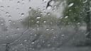
Importantly, both the Atlantic Ocean and the Chesapeake Bay are still quite cold in March, with their water temperatures in the 40s. As a result, the wind arriving in Richmond will be crossing those cold bodies of water, bringing in colder air and a deck of low, gray clouds.
That deck of clouds will be very shallow (if you are flying out of Richmond over the next couple of days, you’ll notice the air above 3000 feet is clear), meaning there is no significant storm system with them. Perhaps some drizzle can get squeezed out of those clouds, but that will be about it.

The forecast problem is figuring out just how far west those low, gray clouds will go, and it is a common issue during the late winter and early spring in Virginia.
It is not unusual to see areas from Richmond to the Chesapeake Bay in the 50s beneath that cloud deck, while farther west toward Charlottesville and Lynchburg, the sun is out and temperatures approach 70.
That is the situation we face Thursday and Friday.
So, how does it actually look?
The best guess right now is that the cloudy and cooler air makes it as far west as the periphery of Richmond on Thursday before advancing even farther westward Thursday night.
All else being equal, it is easier for that cloudy and chilly air to move west during the night, as there is no sunshine to help naturally warm the ground and modify that chilly air and slow its progress.
More than once, I have guessed that the clouds and chilly marine air would remain farther east, forecasting sunshine and a temperature near 70, only to be bitten by that cloud deck and watch the temperature stall in the 50s all afternoon.
So the idea for Thursday is that we get a mix of sunny and cloudier periods, but temperatures hold in the 60s. Friday looks even cloudier — at least in the morning.
While optimistic that the clouds will break late Friday afternoon allowing us back into the 60s, it would not surprise me at all if they locked in all day long, threatening to hold the afternoon in the 50s.

Lunar eclipse above the clouds
By the way, there is a lunar eclipse very early on Friday morning. This is when the moon passes in Earth’s shadow, giving the moon a deep orange appearance. I’m honestly worried we will have a low overcast and miss it entirely, but there is certainly enough wiggle room in the forecast to suggest some breaks in the clouds and a chance to see it.
The peak of it is right around 3 a.m. Friday morning, but there will be some orange hues showing up for a couple of hours between 2 and 4 a.m.
Weekend storminess
Winds increase from the south on Saturday, scouring out that chilly, damp air with an afternoon in the 70s, then the next serious system approaches on Sunday.
Remember about a week ago, we had an afternoon with about two inches of rain in six hours and scattered wind damage?
A small tornado (EF-0) formed over the York River that afternoon and briefly moved on to the Middle Peninsula, into the community of Allmondsville in Gloucester County.
Even though it was on the ground for only a half-mile, several large trees came down in that tornado, and a large propane tank was pushed several hundred feet.

A similar weather situation is expected late this Sunday afternoon and into Sunday night. That is not to say a tornado will form again — much less in the same place — but conditions are expected to turn favorable for some intense squalls capable of wind damage during that time.
Once that system clears early Monday morning, most of next week looks dry with temperatures near or above normal: 60s to near 70 during the day and 40s at night, leaving the next rain likely to wait until Thursday or Friday next week.
No freeze for a while
And there is no sign of significant cold returning during the next couple of weeks either. It may be tempting to believe spring is here to stay, but remember that the average date of the last freeze over the last 120 years is not until April 7.
Having said that, the warming climate is having an impact in Richmond. Over the last 30 years, the average date of the last freeze has moved ahead to April 2.
More fallout from NOAA
In case you missed it last week, a colleague of mine and President-Elect of the American Meteorological Society, Alan Sealls, explained what is going on with the cuts to the National Weather Service and its parent agency, NOAA.
Additional cuts have happened since, and my colleague Dave Jones at StormCenter Communications in Maryland (video above) talked to hurricane scientist Andy Hazelton to explain how these cuts will impact forecasts — especially important when hurricane season arrives.
Thanks for reading. And as always, you can find me on Bluesky.